படிமம்:Meghalaya COVID-19.svg

Size of this PNG preview of this SVG file: 800 × 430 படப்புள்ளிகள். மற்ற பிரிதிறன்கள்: 320 × 172 படப்புள்ளிகள் | 640 × 344 படப்புள்ளிகள் | 1,024 × 551 படப்புள்ளிகள் | 1,280 × 688 படப்புள்ளிகள் | 2,560 × 1,377 படப்புள்ளிகள் | 807 × 434 படப்புள்ளிகள் .
மூலக்கோப்பு (SVG கோப்பு, பெயரளவில் 807 × 434 பிக்சல்கள், கோப்பு அளவு: 157 KB)
சுருக்கம்
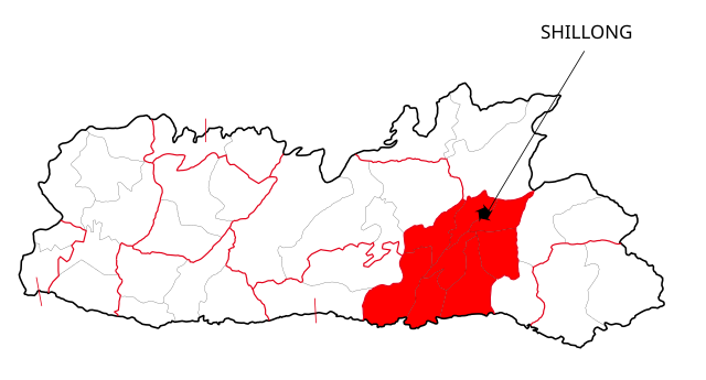
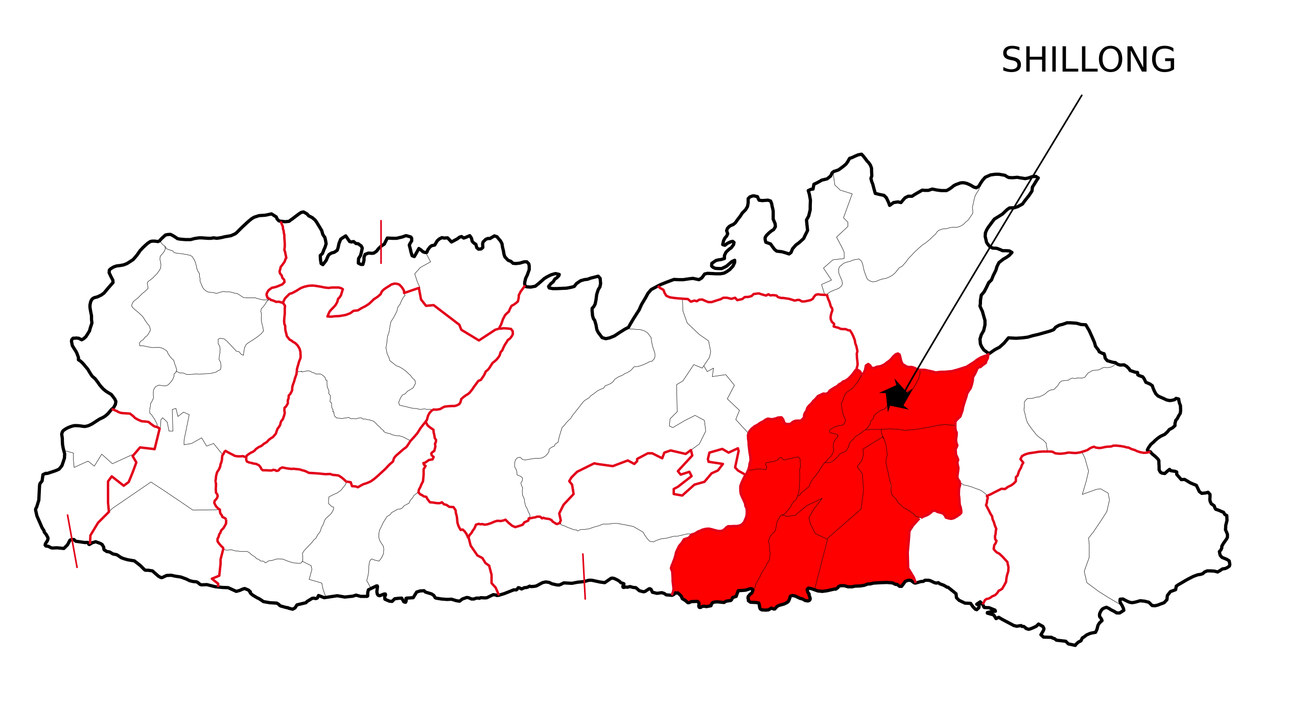
| விளக்கம் | This file shows the districts of Meghalaya affected by COVID-19. |
| நாள் | |
| மூலம் | Meghalaya 2012.svg |
| ஆசிரியர் | Nilabh |
| ஒத்தக்கோப்பு |
[]
|


அனுமதி
இந்த ஆக்கத்தின் காப்புரிமையாளரான நான் இதனைப் பின்வரும் உரிமத்தின் கீழ் வெளியிடுகின்றேன்:
This file is licensed under the Creative Commons Attribution-Share Alike 4.0 International license.
- நீங்கள் சுதந்திரமாக:
- பகிர்ந்து கொள்ள – வேலையை நகலெடுக்க, விநியோகிக்க மற்றும் அனுப்ப
- மீண்டும் கலக்க – வேலைக்கு பழகிக்கொள்ள.
- கீழ்க்காணும் விதிகளுக்கு ஏற்ப,
- பண்புக்கூறுகள் – நீங்கள் பொருத்தமான உரிமையை வழங்க வேண்டும், உரிமத்திற்கான இணைப்பை வழங்க வேண்டும் மற்றும் மாற்றங்கள் செய்யப்பட்டிருந்தால் குறிப்பிட வேண்டும். நீங்கள் ஏற்புடைய எந்த முறையிலும் அவ்வாறு செய்யலாம், ஆனால் எந்த வகையிலும் உரிமதாரர் உங்களை அல்லது உங்கள் பயன்பாட்டிற்கு ஒப்புதல் அளிக்கும் படி பரிந்துரைக்க கூடாது.
- அதே மாதிரி பகிர் – நீங்கள் ரீமிக்ஸ் செய்தாலோ, உருமாற்றம் செய்தாலோ அல்லது பொருளை உருவாக்கினாலோ, உங்கள் பங்களிப்புகளை அல்லது இணக்கமான உரிமம் கீழ் அசலாக விநியோகிக்க வேண்டும்.

|
GNU Free Documentation License விதிமுறைகளின் கீழ் இந்த ஆவணத்தை நகலெடுக்க, விநியோகிக்க மற்றும்/அல்லது மாற்றுவதற்கு அனுமதி வழங்கப்பட்டுள்ளது, Free Software Foundation;ஆல் வெளியிடப்பட்ட பதிப்பு 1.2 அல்லது அதற்குப் பிந்தைய பதிப்பு, மாற்றமில்லாத பிரிவுகள், முன் அட்டை உரைகள் மற்றும் பின் அட்டை உரைகள் இல்லாமல் வெளியிடப்பட்டது. GNU Free Documentation License என்ற தலைப்பில் உரிமத்தின் நகல் சேர்க்கப்பட்டுள்ளது. |
நீர் உமக்கு விருப்பமான உரிமத்தை தேர்ந்தெடுக்கலாம்.
கோப்பின் வரலாறு
குறித்த நேரத்தில் இருந்த படிமத்தைப் பார்க்க அந்நேரத்தின் மீது சொடுக்கவும்.
| நாள்/நேரம் | நகம் அளவு சிறுபடம் | அளவுகள் | பயனர் | கருத்து | |
|---|---|---|---|---|---|
| தற்போதைய | 12:41, 13 மே 2020 | | 807 × 434 (157 KB) | Nilabh Shivam 333 | {{Information |description={{en|1=Districts with confirmed cases in the state of meghalaya, '''as of 12 May 2020'''.}} {{legend|#FF6347|10+ confirmed cases reported}} [https://web.archive.org/web/20040606141014/www.censusindia.net/results/2001maps/assam01.html]. Note: * This map does not show the newer districts that were created after 2014. * The new districts are Chirag, Baksa, Odalguri and Kamrup Metropolitan |Source={{Derived from|Meghalaya 2012.svg|display=50}} |Date=2020-05-13 18:34 (U... |
| 18:31, 4 ஏப்பிரல் 2020 |  | 631 × 530 (348 KB) | Firos ak | == {{int:filedesc}} == {{Information |Description={{en|1=This file shows the districts of en:Assam as of 2001. The map is based on a free hand trace of [https://web.archive.org/web/20040606141014/www.censusindia.net/results/2001maps/assam01.html]. Note: * This map does not show the newer districts that were created after 2001. * The new districts are Chirag, Baksa, Odalguri and Kamrup Metropolitan}} |Source={{Derived from|Assam-districts-2001.svg|display=50}} |Date=2020-04-04 18:31 (UT... | |
| 23:27, 19 ஆகத்து 2011 |  | 631 × 530 (211 KB) | Chaipau | Corrected the following districts: Nalbari, Barpeta, Sivasagar, Tinsukia | |
| 11:02, 5 ஏப்பிரல் 2009 |  | 631 × 530 (165 KB) | Chaipau | The image is cropped to exclude empty spaces. | |
| 01:14, 5 ஏப்பிரல் 2009 |  | 744 × 1,052 (165 KB) | Chaipau | {{Information |Description={{en|1=This file shows the districts of en:Assam as of 2001. The map is based on a free hand trace of [http://web.archive.org/web/20040606141014/www.censusindia.net/results/2001maps/assam01.html]. Note: * This map does not |
கோப்பு பயன்பாடு
பின்வரும் பக்க இணைப்புகள் இப் படிமத்துக்கு இணைக்கபட்டுள்ளது(ளன):
கோப்பின் முழுமையான பயன்பாடு
கீழ்கண்ட மற்ற விக்கிகள் இந்த கோப்பை பயன்படுத்துகின்றன:
- awa.wikipedia.org-திட்டத்தில் இதன் பயன்பாடு
- ca.wikipedia.org-திட்டத்தில் இதன் பயன்பாடு
- eu.wikipedia.org-திட்டத்தில் இதன் பயன்பாடு
- hi.wikipedia.org-திட்டத்தில் இதன் பயன்பாடு
- असम
- दरंग जिला
- बंगाईगाँव जिला
- नलबाड़ी जिला
- जोरहाट जिला
- कार्बी आंगलोंग जिला
- कामरूप जिला
- कोकराझार जिला
- बरपेटा जिला
- डिब्रूगढ़ जिला
- धेमाजी जिला
- धुबरी जिला
- तिनसुकिया जिला
- गोवालपारा जिला
- लखीमपुर जिला
- भारत के ज़िले
- डिमा हासाओ जिला
- करीमगंज जिला
- गोलाघाट जिला
- नगाँव जिला
- मरिगाँव जिला
- शिवसागर जिला
- शोणितपुर जिला
- हाईलाकांदी जिला
- काछार जिला
- चिरांग जिला
- बाक्सा जिला
- उदलगुड़ी जिला
- कामरूप महानगर जिला
- विश्वनाथ जिला
- होजाई जिला
- चराईदेव जिला
- माजुली जिला
- kk.wikipedia.org-திட்டத்தில் இதன் பயன்பாடு
- mai.wikipedia.org-திட்டத்தில் இதன் பயன்பாடு
சிறப்பு பக்கம்-மொத்த பயன்பாடு - இதன் மூலம் இந்த கோப்பின் மொத்த பயன்பாட்டை அறிய முடியும்