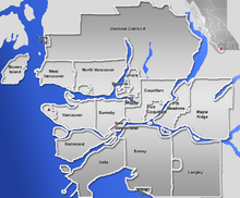
படிமம்:GVA-map.png

இந்த முன்னோட்டத்தின் அளவு: 724 × 600 படப்புள்ளிகள் . மற்ற பிரிதிறன்கள்: 290 × 240 படப்புள்ளிகள் | 579 × 480 படப்புள்ளிகள் | 846 × 701 படப்புள்ளிகள் .
மூலக்கோப்பு (846 × 701 படவணுக்கள், கோப்பின் அளவு: 223 KB, MIME வகை: image/png)
கோப்பின் வரலாறு
குறித்த நேரத்தில் இருந்த படிமத்தைப் பார்க்க அந்நேரத்தின் மீது சொடுக்கவும்.
| நாள்/நேரம் | நகம் அளவு சிறுபடம் | அளவுகள் | பயனர் | கருத்து | |
|---|---|---|---|---|---|
| தற்போதைய | 21:07, 2 சனவரி 2007 |  | 846 × 701 (223 KB) | Qyd | pale sea |
| 20:25, 2 சனவரி 2007 |  | 846 × 701 (231 KB) | Qyd | {{Information |Description=Blank map of the Greater Vancouver Area, [[British Columbia, Canada |Source=GIS data |Date=Jan 2007 |Author={{User|Qyd}} |Permission=All |other_versions=Image:Greater Vancouver Area.png (with municipalities names) } |
கோப்பு பயன்பாடு
இப் படிமத்துக்கு இணைக்கப்பட்டுள்ள பக்கங்கள் எதுவும் இல்லை.
கோப்பின் முழுமையான பயன்பாடு
கீழ்கண்ட மற்ற விக்கிகள் இந்த கோப்பை பயன்படுத்துகின்றன:
- ar.wikipedia.org-திட்டத்தில் இதன் பயன்பாடு
- en.wikipedia.org-திட்டத்தில் இதன் பயன்பாடு
- eo.wikipedia.org-திட்டத்தில் இதன் பயன்பாடு
- fa.wikipedia.org-திட்டத்தில் இதன் பயன்பாடு
- الگو:Location map Canada Vancouver
- فرودگاه بینالمللی آبی ونکوور
- الگو:Location map Canada Vancouver/توضیحات
- الگو:Location map Canada Vancouver/doc
- بیمارستان زنان و مرکز سلامت بی.سی.
- موزه مردمشناسی دانشگاه بریتیش کلمبیا
- مترو ونکوور
- انگلیش بی، ونکوور
- پل لاینز گیت
- گستاون
- گالری هنر ونکوور
- متروتاون، برنابی
- رنفرو–کولینگوود
- fr.wikipedia.org-திட்டத்தில் இதன் பயன்பாடு
- id.wikipedia.org-திட்டத்தில் இதன் பயன்பாடு
- ja.wikipedia.org-திட்டத்தில் இதன் பயன்பாடு
- kn.wikipedia.org-திட்டத்தில் இதன் பயன்பாடு
- pl.wikipedia.org-திட்டத்தில் இதன் பயன்பாடு
சிறப்பு பக்கம்-மொத்த பயன்பாடு - இதன் மூலம் இந்த கோப்பின் மொத்த பயன்பாட்டை அறிய முடியும்
